Lake Michigan Fishing Spot
- Public Fishing: Yes
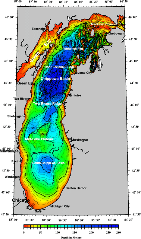
- Mean Depth: 279'
- Max Depth: 925'
- Elevation: 722'
- Shoreline: 1638'
- Last Modified By: carpmaster on 12/05/09 08:08 PM
- Ask about Lake Michigan in our Fishing Forums
Photos
Fish Species
Comments
-
Have you fished at Lake Michigan? Be the first to comment on this fishing spot.
Lake Michigan Description
Here's a link to a larger bathymetric image for Lake Michigan http://www.ngdc.noaa.gov/mgg/image/michwallposter.jpg
Great Lakes Fact Sheet
The Great Lakes contain about 23,000 km3 (5,500 cu.mi.) of water, covering a total area of 244,000 km2 (94,000 sq. mi.) The Great Lakes are the largest system of fresh, surface water on Earth, containing roughly 21 percent of the world supply and 84 percent of North America's supply. Only the polar ice caps contain more fresh water.
The Great Lakes basin is home to 25 million people in the United States and 8.5 million in Canada. This means that about 10 percent of the U.S. population and 31 percent of the Canadian population live in the Great Lakes basin.
In spite of their large size, the Great Lakes are sensitive to the effects of a wide range of pollutants. The sources of pollution include the runoff of soils and farm chemicals from agricultural lands, the waste from cities, discharges from industrial areas and leachate from disposal sites. The large surface area of the lakes also makes them vulnerable to direct atmospheric pollutants that fall as rain, snow, or dust on the lake surface, or exchange as gases with the lake water.
--------------------------------------------------------------------------------
Some Physical Features of the Great Lakes
Great Lake
Totals
Feature Units Superior
Michigan
Huron
Erie
Ontario
Average Deptha feet 483 279 195 62 283
meters 147 85 59 19 86
Maximum Deptha feet 1,332 925 750 210 802
meters 406 282 229 64 244
Volumea miles3 2,900 1,180 850 116 393 5,439
km3 12,100 4,920 3,540 484 1,640 22,684
Water Area miles2 31,700 22,300 23,000 9,910 7,340 94,250
km2 82,100 57,800 59,600 25,700 18,960 244,160
Land Drainage Areab miles2 49,300 45,600 51,700 30,140 24,720 201,460
km2 127,700 118,000 134,100 78,000 64,030 521,830
Shoreline Lengthc miles 2,726 1,638 3,827 871 712 10,210d
km 4,385 2,633 6,157 1,402 1,146 17,017d
Population: U.S. 1990 425,548 10,057,026 1,502,687 10,017,530 2,704,284 24,707,075
Canada 1991 181,573 1,191,467 1,664,639 5,446,611 8,484,290
Totals:
607,121 10,057,026 2,694,154 11,682,169 8,150,895 33,191,365
Retention Time years 191 99 22 2.6 6
Notes:
a Measured at Low Water Datum.
b Land Drainage Area for Lake Huron includes St. Marys River.
Lake Erie includes the St. Clair-Detroit system.
Lake Ontario includes the Niagara River.
c Including islands.
d These totals are greater than the sum of the shoreline length for the lakes because they include the connecting channels (excluding the St. Lawrence River).
Source: Great Lakes Atlas
--------------------------------------------------------------------------------
Outflows from the Great Lakes are relatively small (less than 1 percent per year) in comparison with the total volume of water. Pollutants that enter the lakes - whether by direct discharge along the shores, through tributaries, from land use or from the atmosphere - are retained in the system and become more concentrated with time. Also, pollutants remain in the system because of resuspension (or mixing back into the water) of sediment and cycling through biological food chains.
Lake Superior is the largest in terms of volume. It is also the deepest and coldest of the five. Because of its size, Superior has a retention time of 191 years. Retention time is a measure based on the volume of water in the lake and the mean rate of outflow. Most of the Superior basin is forested, with little agriculture because of a cool climate and poor soils. The forests and sparse population result in relatively few pollutants entering Lake Superior, except through airborne transport [ Lake Superior bathymetric map].
Lake Michigan, the second largest, is the only Great Lake entirely within the United States. The northern part is in the colder, less developed upper Great Lakes region. It is sparsely populated, except for the Fox River Valley, which drains into Green Bay. This bay has one of the most productive Great Lakes fisheries but receives the wastes from the world's largest concentration of pulp and paper mills. The more temperate southern basin of Lake Michigan is among the most urbanized areas in the Great Lakes system. It contains the Milwaukee and Chicago metropolitan areas. This region is home to about 8 million people or about one-fifth of the total population of the Great Lakes basin.
There are 3 species of Salmon in Lake Michigan. The very common Chinook and Coho Salmon as well as the uncommon Pink Salmon.
Lake Michigan is one of the five Great Lakes of North America, and the only one located entirely within the United States. The third-largest of the Great Lakes, it is bounded, from west to east, by the U.S. states of Wisconsin, Illinois, Indiana, and Michigan. The word "Michigan" was originally used to refer to the lake itself, and is believed to come from the Ojibwa Indian word mishigami, meaning "great water."[2] The lake is slightly larger than the country of Croatia.